What does the Site currently look like?
The Site lies within a low lying, gently undulating landform with a mosaic of fields frequently with mature tree hedgerow within a rural setting. The majority of the Site is currently under intensive wheat production with rough grassland margins. There are several Public Rights of Way within and around the Site. The Site is adjacent to Ancient Woodland, Pollards Wood. There are also waterbodies and field drains across the Site.
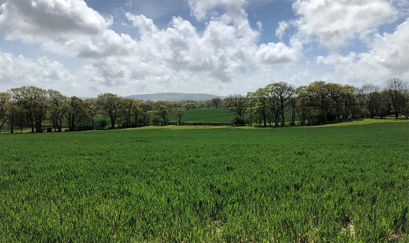
Above: View across land proposed as Pollards Solar Farm from Public Right of Way
What will Pollards Solar Farm look like?
Although the potential visibility of the proposed PV panels will be close-distance views, the visual effect on the wider landscape and visual receptors will be limited. The Site would be discernible from the higher parts of South Downs National Park to the south. However, the visibility of the Proposed Development would be distant occupying a small proportion of panoramic views from the National Park and views filtered by surrounding hedgerows, small woods and landform.
The area of the surrounding landscape that would be theoretically visible from the Site (known as the Zone of Theoretical Visibility (ZTV)) is shown on the figure below.
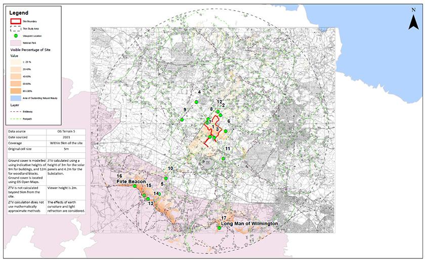
Above: Zone of Theoretical Visibility (ZTV) and Viewpoint Locations. View a larger version of this map.
The table below lists the viewpoints (VPs) from which the visual impacts of the Site have be considered to date.
Representative Viewpoint | View Point Description |
VP1 | Users of PRoW Footpath Claverham Manor FP 12a looking north towards the Application Site near distance |
VP2 | Users of PRoW Footpath 44, 530m south east of Marnhull Farm looking south towards the Application Site – near distance |
VP3 | Users of PRoW Footpath 12b near Wick Farm with in the Application Site and looking north and west |
VP4 | Users of local road Deanland Rd near Deanland Wood Park looking east towards the Application Site – mid distance |
VP5 | Users of PRoW RUPP on Wealden Way east of Bopeep Farm looking north towards the Application site – long distance |
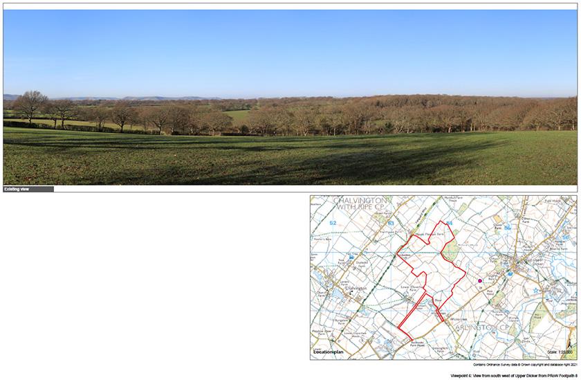
VP6 | Users of PRoW footpath 8, south west of Upper Dicker looking west towards the Application Site – near distance |
VP7 | Users of PRoW footpath 41 within north west part of the Application Site, looking eastwards towards the rest of the Site - near distance |
VP8 | PRoW footpath part of the Vanguard Way looking south east towards the Application Site |
VP9 | Users of PRoW footpath Fowlers Barn - north Ripe looking eastwards towards the Application Site – mid distance |
VP10 | Users of PRoW footpath Cuckmere Way jnc with Common lane, looking north towards the Application Site – long distance |
VP11 | Users of PRoW footpath north of Arlington looking westwards towards the Application Site – mid distance |
VP12 | Users of PRoW footpath between Upper Dicker and Marnhull Farm House looking south towards the Application Site – near distance |
VP13 | South Downs Way near Bopeep car park looking north towards the Application site – long distance |
VP14 | Bostal Hill viewpoint off the South Downs Way – looking north towards the Application Site – long distance |
VP15 | Tumuli near Loose Plantation viewpoint off the South Downs Way looking north towards the Application Site – long distance |
VP16 | Firle Beacon - landmark viewpoint on the South Downs Way looking north towards the Application Site – long distance |
VP17 | Long Man of Wilmington - landmark viewpoint on the South Downs Way looking north towards the Application Site – long distance |
As part of the planning application submission, a Landscape and Visual Assessment will be included within the ES. Following the Scoping Response from the Council, further VPs will be considered within the ES and the ZTV will be expanded to address consultee comments.
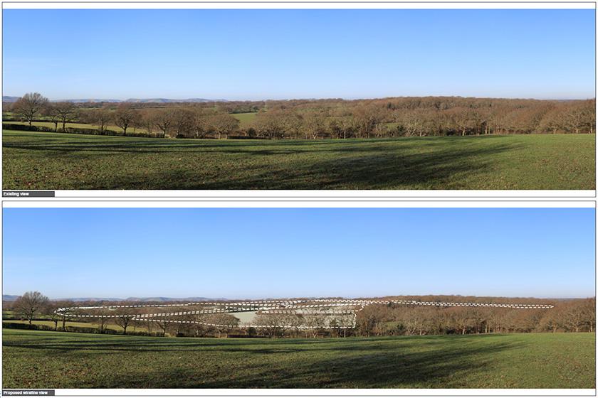
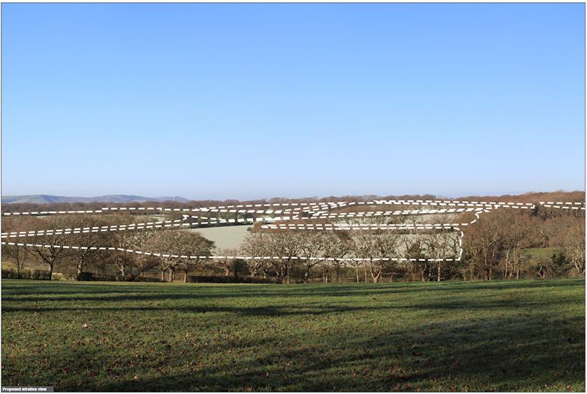
Photomontages of the Proposed Development will also be included within the ES to illustrate the scheme within the landscape. Based on the current layout, a single photomontage (from Viewpoint Location 6) has been provided prior to the submission of the ES to provide attendees with a realistic impression of the Proposed Development