What Will It Look Like?
The proposed Development will result in changes to views and it is important to show what it would potentially look like as part of the landscape. It is also important that a transparent and objective assessment of potential changes to landscape and views resulting from the proposed Development is made using established guidance and procedures.
Landscape and Visual Impact Assessment (LVIA)
An LVIA is being undertaken in line with NatureScot (formerly Scottish Natural Heritage (SNH)) and The Highland Council (THC) requirements and in accordance with guidance from the Landscape Institute. The LVIA examines effects on both the landscape and the views and visual amenity experienced by people living and visiting the area.
The LVIA will use a series of viewpoints representative of views experienced from publicly accessible locations in the area. Through the Direct Scoping process, viewpoints have been agreed with THC, NatureScot and other consultees as appropriate and photographs have been taken at each viewpoint by a professional photographer.
A series of visualisations will be prepared for each viewpoint. These will be a mix of photomontages and wireline representations of the proposed Development.
The viewpoints and photography form part of the information used to inform a systematic and objective assessment of the potential impacts of the proposed Development on landscape, views and visual amenity of the area surrounding the Site.
What we will do...
The findings of the ongoing LVIA will be presented in the associated EIA Report Chapter and Technical Appendices, which will be made publicly available on the SPR website once the Section 36 application has been submitted to the ECU in Spring 2021.
Zone of Theoretical Visibility (ZTV)
The ZTV illustrates theoretical visibility of wind turbines of the proposed Hollandmey Renewable Energy Development, based on what is referred to as a bare earth model. It does not include the screening effect of ground cover features, such as vegetation and buildings, which typically reduce the amount of actual visibility of turbines.
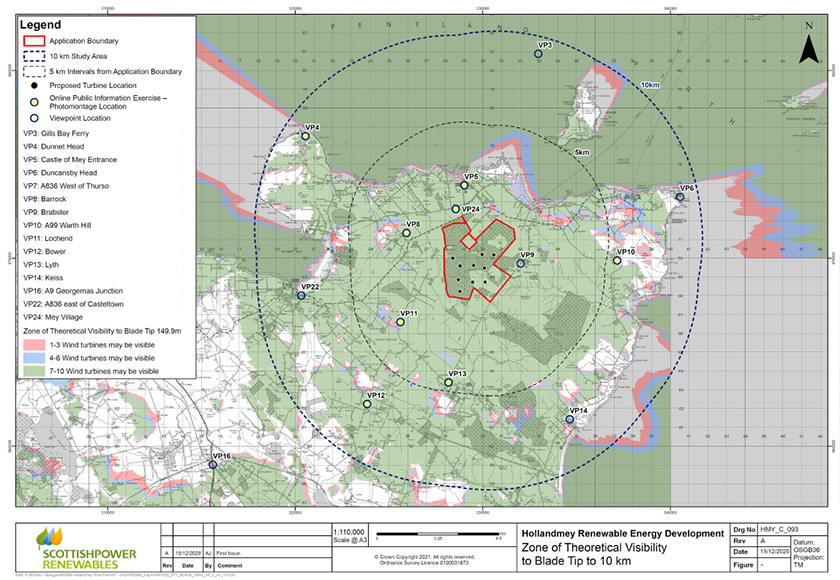
View a larger version of the above map
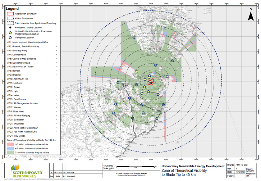 View a larger version of the above map
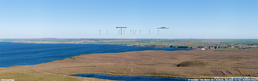
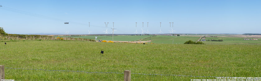
Visualisations
Click the links below to view photomontages from each location.
Viewpoint 04 - Dunnet Head
Viewpoint 04 is at the Trig point and viewing area in Dunnet Head Special Landscape Area (SLA).
Viewpoint 05 - Castle of Mey
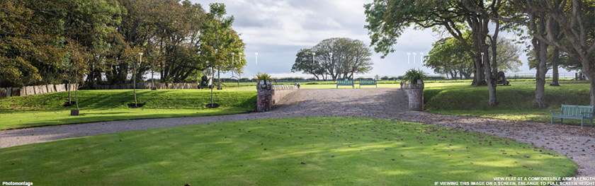
Viewpoint 05 is in Castle of Mey Garden and Designed Landscape (GDL) and is positioned at the south entrance to the castle as requested by Historic Environment Scotland (HES)*.
Viewpoint 08 - Barrock
Viewpoint 08 is located at the eastern edge of Barrock where views are more open than in the central and western parts of the settlement.
Viewpoint 10 - A99 Warth Hill
Viewpoint 10 is located near a Trig point at Warth Hill to the west of and above the A99, which is the route of the North Coast 500 (NC500).
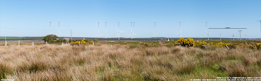
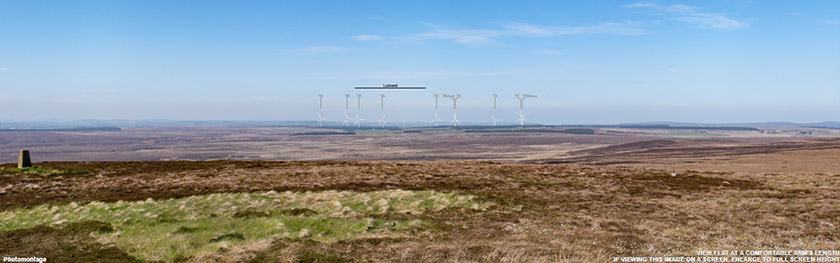
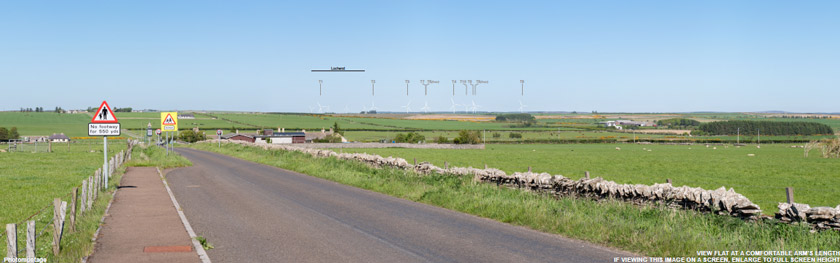
Viewpoint 11 - Lochend
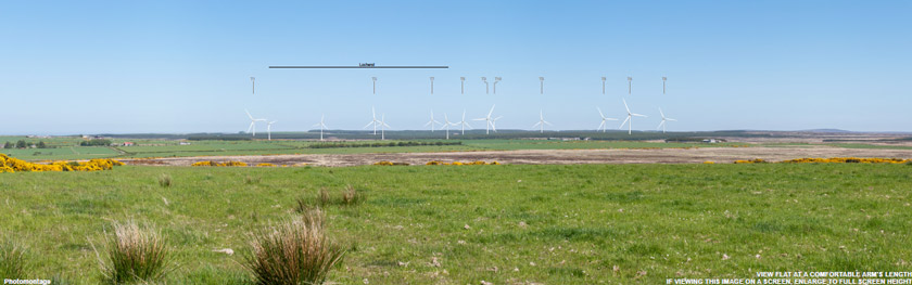
Viewpoint 11 is located near the Trig point on the minor road that leads to Lochend.
Viewpoint 12 - Bower
Viewpoint 12 is located on a footway that runs alongside the minor road to the north of Bower Parish Church.
Viewpoint 13 - Lyth
Viewpoint 13 is located near the war memorial on the minor road to the east of the cross-roads at Lyth.
Viewpoint 24 - Mey Village
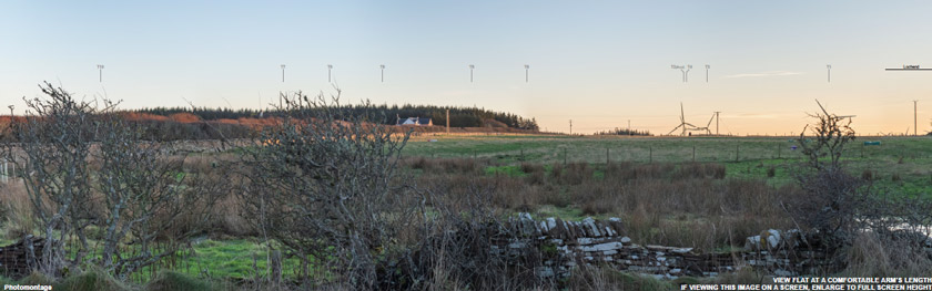
Viewpoint 24 is from the eastern part of Mey village where there are a number of residential properties with views in the direction of the proposed Development.
* The agreed viewpoint location provides a general representation of views from a specific location requested by HES. In this locality views of wind turbines would be partly interrupted by landform and vegetation.
Go back to the main pageGo to the next page