Note: Solar glint and glare were identified as a consideration at the scoping stage, but have now been scoped out based on comments received from The Highland Council.
Background
SPR have conducted an extensive site investigation and design process that began with a pre-application advice pack from THC and was supplemented by further feasibility studies, environmental surveys, and consultation. This has resulted in the final design, which is currently being assessed. The scope of the EIA has been agreed with key consultees and is intended to be proportionate and robust.
Establishing a detailed ecological record of the Site has enabled us to develop the design in a manner that avoids or minimises adverse effects on sensitive habitats and protected species.
We have…
- Undertaken a series of desk-based studies and consultations with organisations including NatureScot, RSPB and Local Fisheries Boards to identify existing records of species and habitats;
- Undertaken baseline ecological surveys on site for protected species and habitats; and
- Undertaken baseline ornithological surveys (including breeding and wintering bird and flight activity surveys) in 2017, 2018, 2019 and 2020.
We found…
The Site primarily consists of commercially managed forestry but supports some areas of sensitive bog and heathland habitats located within the Phillips Mains Mire Site of Special Scientific Interest (SSSI). The Caithness and Sutherland Peatlands Special Area of Conservation (SAC), designated for its important moorland habitat and otter interests is also located south east of the Site. Surveys undertaken have found evidence of protected species including water vole, bats and otter, with the habitats present within the Site also suitable for a number of other protected species including red squirrel and pine marten.
There are three international designated areas nearby which will require consideration (along with their component SSSIs where applicable) in our ornithology assessments: Caithness and Sutherland Peatlands SPA and Ramsar site (c 1 km from the application boundary); Caithness Lochs SPA and Ramsar site (Loch of Mey and Loch Heilan c 1.5 km and 2 km respectively from the application boundary); and North Caithness Cliffs SPA (3.5 km at its nearest point from the application boundary).
Two years of bird surveys have been completed and survey results indicate that there are no scarce birds of conservation concern breeding or roosting within the survey buffers of the Site.
What we will do…
As some flights by SPA species, including wintering geese and swans, passed within the survey buffers, a full assessment of potential effects on these species and the integrity of the designated areas will be completed.
Protecting Species and Habitat
SPR will seek to mitigate impacts on ecology in a variety of ways by:
- Avoiding construction during the bird breeding season where possible, or where not possible undertaking surveys to identify and protect any nesting birds;
- Avoiding watercourses and areas of sensitive blanket bog habitats identified during the Phase 1/NVC vegetation surveys where possible;
- Adopting safe working buffers where protected species are found;
- Adopting pollution control measures to prevent silt or dusts entering watercourses; and
- Designing any new or upgraded watercourse crossings to maintain safe passage of fish.
Any potential adverse effects for any species will be mitigated to meet legislative requirements and good practice, with species-specific mitigation plans created where required.
SPR will also identify opportunities for ecological enhancement, either through onsite habitat management or through consultation with conservation organisations to support existing biodiversity projects. During the first Public Information Event, feedback was received from a member of the public detailing the biodiversity potential of the Dubh Lochans on Site and SPR are looking at the potential to incorporate positive enhancement measures as part of the Habitat Management Plan (HMP) for the proposed Development.
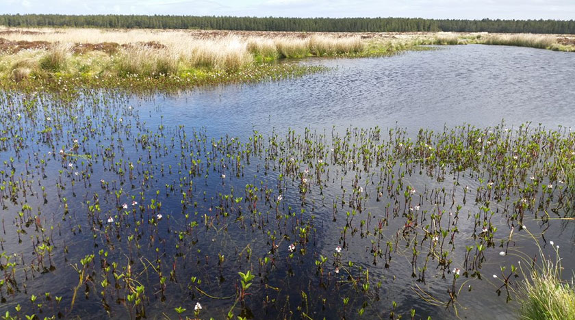
Above: Bog pools in the Philip Mains Mire
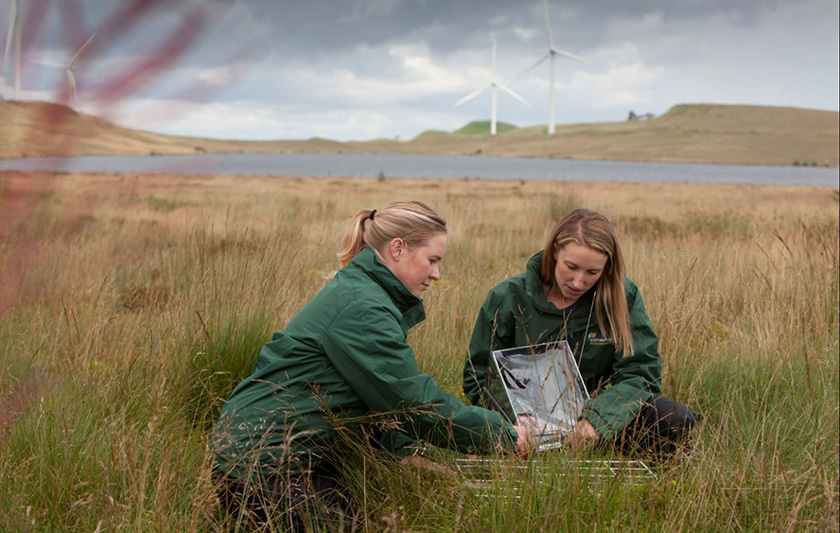
Above: SPR’s inhouse ecology team conducting conservation fieldwork
Our understanding of the ground conditions and surface water network informed the Site design. This minimises the risk of groundwater and surface water being adversely affected. Our technical specialists work closely with one another to ensure that the potential effects of the proposed Development on hydrology and related habitats and species are considered holistically. This is particularly important for Groundwater Dependent Terrestrial Ecosystems (GDTEs), for example.
We have…
Assessed watercourses on the Site and avoided them as far as possible in the design process, investigated peat depths across the Site, identified the location of private water supplies near the Site and the potential for flooding from Site watercourses.
We found...
Our technical teams have identified the key hydrological components in and around the proposed Development. This allows us to understand how rainfall and surface water run off infiltrate into soils and peat and discharge into watercourses and drainage channels.
This information will also allow us to assess whether any private water supplies are potentially at risk of being affected by construction works.
Peat surveys identified peat deposits of variable depth across the Site, including some areas where there is no peat present. Our design avoids the areas of deepest peat where possible.
What we will do…
Where peat cannot be avoided, location-specific mitigation measures will be set out to minimise effects on peat. This is planned to include peatland restoration proposals for suitable areas.
Protecting Watercourses during Construction
During the construction phase, pollution of water entering watercourses will be prevented through a range of measures including the use of silt traps, settlement ponds and cut off drains, as well as a surface water monitoring programme. This is to ensure that water quality in all downstream watercourses is protected and maintained.
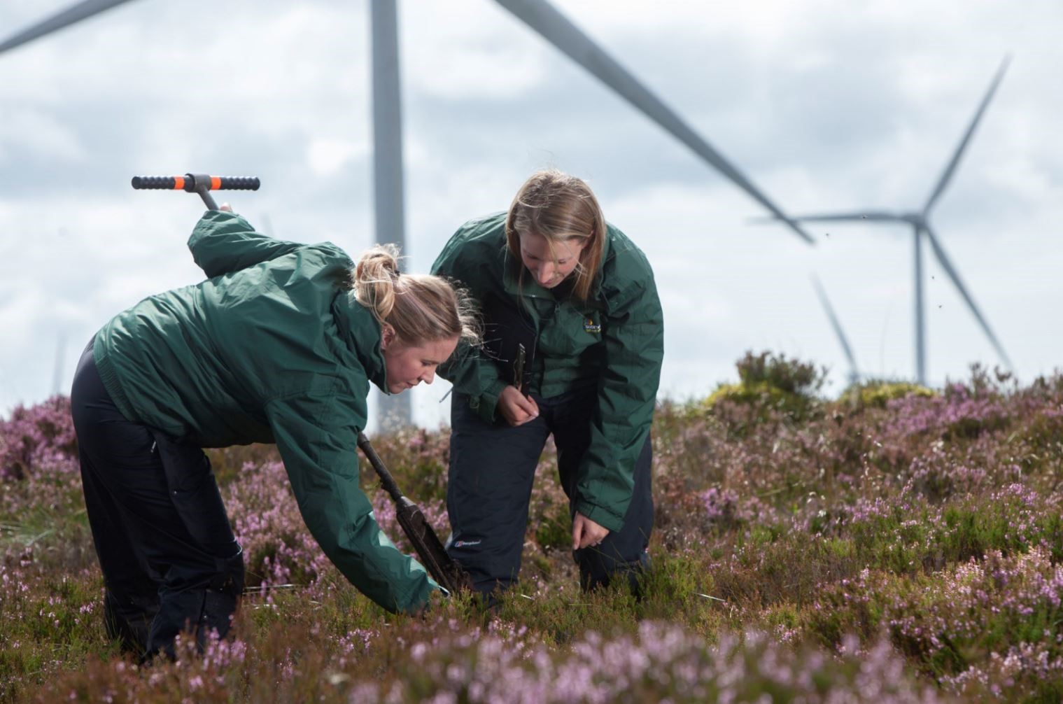
Above: SPR’s inhouse Ecology Team conducting onsite fieldwork
Archaeology relates primarily to the buried remains and artefacts that could be affected by the construction works related to the building of the proposed Development.
Cultural heritage generally relates to other sites, features and locations in the wider landscape which have the potential to have their setting affected by the proposed Development.
We have…
Undertaken a desk-based study of the Site and surrounding areas to identify all known assets registered with national and local archaeological bodies. Completed a site walkover to investigate potential for archaeological remains and visited key historical assets in the surrounding area to assess potential impacts to setting. Detailed consultation is ongoing with Historic Environment Scotland (HES) regarding the impact assessment.
We found…
No designated heritage assets (World Heritage Sites, Inventory Historic Battlefields, or Inventory Gardens and Designed Landscapes) are found within the proposed Development boundary. There are 15 known undesignated assets recorded in The Highland Council’s Historic Environment Record (HER). These include four shielings or possible shielings, four sheepfolds, six farmsteads or possible farmsteads and one possible broch. In addition, survey of the site identified 19no. further heritage assets from first edition OS mapping, historical aerial photography, and walkover survey. These assets comprise three wells, six quarries, an enclosure, a re-erected/modern boundary stone and seven areas of rig and furrow (no longer extant). The findings will be presented in the EIA Report.
Several designated assets are present within 20 km of the Site. Of these, there are a number that might have their setting affected during the operational phase of the proposed Development. These assets are the Castle of Mey Inventory Garden and Designed Landscape (c 1.8 km from the application boundary), which provides the setting for the Castle of Mey Category A Listed Building; and two Scheduled Monuments known as Earl’s Cairn and Thomsonfield Broch. (c 1.6 km west and 1.8km east from the application boundary, respectively); Each of these key assets have been visited by a heritage consultant and the outcome of their assessments, including visualisation (wireframe or photomontage), will be presented in the EIA Report.
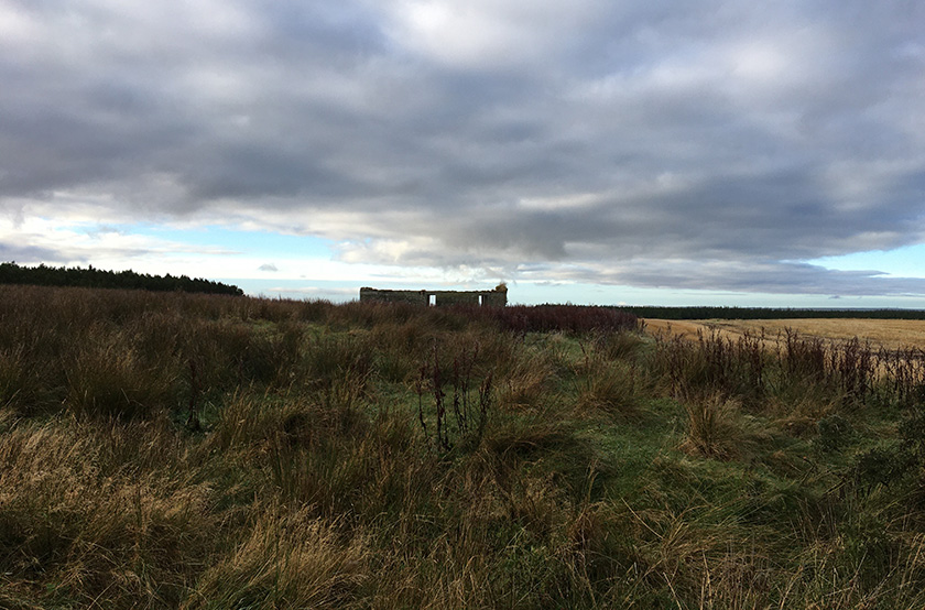
Above: The Highland Council Historic Environment Record heritage asset MHG56454: Scoolary Farmstead, along with all built heritage assets within the site boundary, have been avoided by the proposed Development layout
What we will do…
Archaeology and Cultural Heritage assessments are ongoing and will be informed by the findings and analysis of other environmental studies and feedback from consultees.
Protecting Assets during Construction
The protection of assets has been a key consideration during the EIA process and proposed mitigation measures have evolved as our understanding of the nature of the characteristics of the proposed Development and the receiving environment has improved over the course of the design process and assessment. Relevant mitigation measures will be included in the EIA Report.
We have…
SPR is undertaking a detailed study of the noise environment. This has included using existing background noise data from assessments for nearby windfarms and noise modelling to predict likely levels of wind turbine noise. Existing and predicted levels of windfarm noise will be considered against the current guidance to determine whether the scale of impacts will be significant.
We found…
The nearest noise sensitive receptors considered to be representative of residential dwellings in the immediate vicinity have been identified. The potential impact of noise from the proposed Development was continuously assessed during the design process, and the layout refined through the appropriate siting of turbines in relation to the noise sensitive receptors.
What we will do…
Noise assessments are ongoing. and will be informed by the findings and analysis of other environmental studies and feedback from consultees.
Protecting Residents during Construction
Noise from construction activities will be controlled through the use of a Construction Environmental Management Plan (CEMP).
We have…
SPR and our technical consultants have undertaken a preliminary assessment of the potential impacts on access, traffic and transport. This considered the potential effects of the proposed Development on the transport network, primarily in relation to construction vehicles.
Further studies also considered the route to the Site from the nearby ports, and the potential for environmental effects of vehicles using the public road network.
We found…
Abnormal load access is anticipated to be from the A836, bringing the turbine components from either from the Ports of Scrabster or Wick.
Potential routes from the Ports of Scrabster and Wick for the delivery of wind turbine blades and other components have been identified in an initial route survey report. These routes will be assessed in the route access study, which will also consider alternatives to ensure that the most appropriate route is chosen.
What we will do…
Traffic and transport assessments are ongoing. SPR and our technical consultants will undertake a detailed assessment of the potential impacts on access, traffic and transport which will be informed by the findings and analysis of other environmental studies and feedback from consultees.
Protecting Road Users and Residents
In order to minimise the impact on local residents and other road users, a Construction Environmental Management Plan (CEMP) and a Traffic Management Plan (TMP) will be produced. The following practices will be used:
- Construction vehicles to use approved access routes and adhere to any necessary restrictions;
- Erection of appropriate temporary signage in the vicinity of the Site warning of construction traffic and warning other users of abnormal load turbine movements;
- Abnormal loads will be escorted from the port of entry with timings agreed with the road authorities and police as appropriate;
- Ground preparation, including protection of services; and
- Arrangements for road maintenance, wheel washing and road sweeping where necessary.
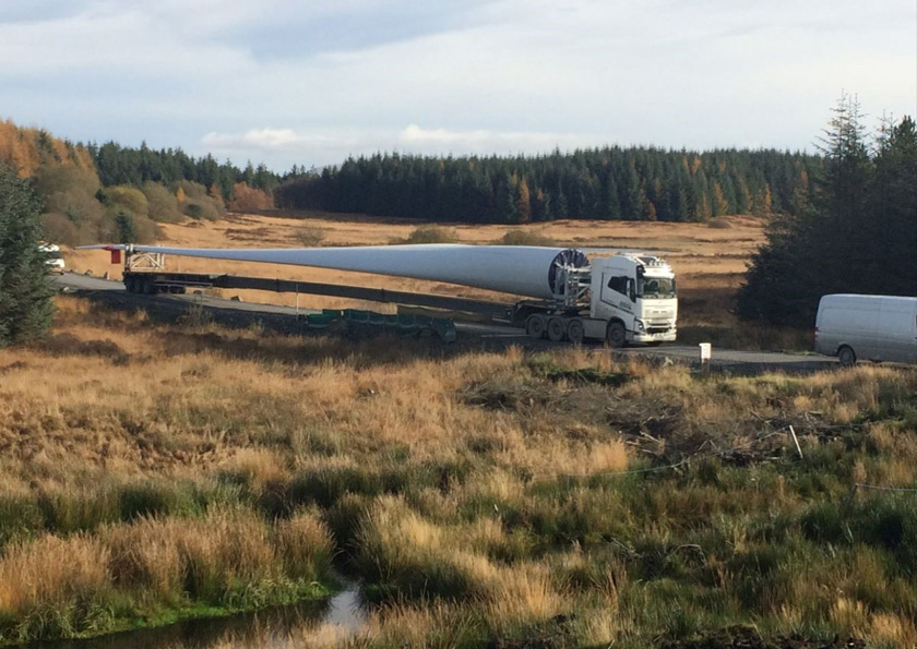
Above: Image shows delivery vehicle with 57 m blade, Hollandmey RED blades will be up to 64.5 m in length
An assessment of the potential socio-economic, tourism and recreation impacts of the proposed Development is being undertaken as part of the Environmental Impact Assessment Report.
We have…
Reviewed the existing baseline conditions, including the identification of community councils, local interest groups, tourist attractions and public access.
Local interest groups were included in scoping consultation, giving them the opportunity to consider the proposed Development and assist with the collection of baseline data, scrutinise the proposed scope of and approach to impact assessment, and provide feedback regarding any concerns they may have.
An assessment of the potential effects of the proposed Development against these baseline conditions will be undertaken as part of the Environmental Impact Assessment.
We found...
The construction and operation of the proposed Development has the potential to benefit the local and regional economies through:
- Direct construction and operation employment opportunities;
- Indirect employment further down the supply chain for those companies providing services to the Contractors during the construction and operation phases of the development;
- Indirect employment within the local economy arising from the proposed Development’s work force spend on accommodation and subsistence; and
- Contribution to a Community Benefit Fund
What we will do...
Assessments are ongoing and will be informed by the findings and analysis of other environmental studies and feedback from consultees.
As a minimum SPR is committed to:
- Seeking to use local labour where practical to maximise the benefits to the local economy;
- Making provision for access during the operation of the proposed Development;
- Continuing to consult with recreational groups to identify and respond to any opportunities and areas of concern;
- Engaging with local schools and educational establishments to share knowledge and build relationships; and
- Working with the community to develop the Community Benefit and investment opportunities in a way that responds to their needs.
Wind turbines have the potential to interfere with military and civil aviation operations, primarily through effects on surveillance radar and communication and navigation equipment, but also as a physical obstruction if they are sited within military low flying areas.
We have…
Consulted with relevant stakeholders (MOD, CAA, NATS, Highland and Islands Airport, BAA Edinburgh, BAA Glasgow and Glasgow Prestwick Airport) in order to understand the current context and to identify any constraints.
We found…
The proposed Development is in an area remote from military aviation infrastructure, approximately 16 km to the north of Wick Airport. The Site is outside the Aerodrome Traffic Zone, but underneath or close to several of the instrument approach procedures published for the airport.
What we will do…
- An assessment of civil and military aviation issues will be undertaken; and
- Input will be obtained from the specialist consultants should any issues be identified that require mitigation or detailed technical assessment, including line-of-sight assessments.
Wind turbines can potentially cause interference to telecommunication system signals through reflecting and shadowing telecommunication signals between transmitters and receivers.
We have…
Undertaken consultation with relevant bodies to establish the presence of utilities and telecommunication links across the Site.
Conducted a Telecommunications Impact Assessment to identify the links that might be affected by the proposed Development and potential mitigation measures.
We found…
Consultation has been undertaken with Spectrum Licensing (Ofcom) who confirmed that there are several telecommunications links in the vicinity of the Site.
SSE operate a powerline connecting Lochend Windfarm which runs through the southern portion of the Site. The location of this has been avoided during design development.
What we will do…
- Any potential information on communication links will be sought through consultation with relevant link operators.
- An assessment will be undertaken to determine the significance of any potential operational effects and where appropriate, suitable mitigation measures will be discussed with the link operator
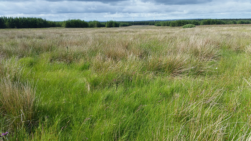
Above: Marshy grassland within the Site looking west to Lochend Wind Turbines.
Shadow flicker is an effect caused by the rotation of the turbine blades when the sun is shining, which can create a flickering or strobe-like effect. This can be a cause of annoyance at residences near wind developments.
We have…
Reviewed the regional and national policy on shadow flicker and identified residential properties within 2 km of the application boundary.
We found…
There are no formal guidelines currently available on what exposure would be acceptable in relation to shadow flicker. There is no standard for the assessment of shadow flicker. The Scottish Government’s web-based guide relating to onshore wind turbines (Scottish Government 2013) suggests that as a general rule shadow flicker should not pose problems beyond a distance of 10 rotor diameters from a wind turbine, which equates to a maximum of 1500 m in this instance.
Department of Environment and Climate Change studies have shown that in northern latitudes shadows from wind turbines can only be cast 130 degrees either side of north relative to the turbine due to the orientation of the Earth’s axis and the positioning of the Sun.
This equates to a region of 50 degrees either side of due south where a wind turbine would never cast a shadow and therefore properties within this region would experience no effects from shadow flicker.
What we will do…
The proposed Development has been designed where possible to avoid turbine placements within the Zone of Potential Shadow Flicker (ZPSF). A shadow flicker assessment will be undertaken as part of the EIA, and if it is not possible to avoid shadow flicker effects through turbine placement, then the dates, times and durations of shadow flicker events for each property within the ZPSF will be calculated and an assessment of effects at these properties also included in the EIA.
The proposed Development, once operational, would generate zero carbon energy which would help to offset the release of greenhouse gas (GHG) emissions by fossil fuel-dependent energy generation. During their construction and decommissioning, however, renewable energy developments can themselves result in GHG emissions, for example from turbine manufacture and site preparation. This is particularly the case where natural carbon stores such as forestry or peat are present and potentially impacted by the development. These resulting GHG emissions, however, are normally offset by developments of this nature within 1.5 to 2 years of operation.
We have…
Avoided siting wind turbines within the areas of deepest peat throughout the design process.
What we will do…
To minimise peat disturbance during construction, especially during excavation, Best Practicable Measures will also be considered that will be provided as part of the Construction Environmental Management Plan (CEMP).
A Carbon Balance Assessment will be prepared in accordance with best practice guidance to outline the time taken for the carbon impact of the proposed Development to be reversed by the zero-carbon electricity generation.
The current land use of the Site is predominantly commercial forestry.
We have…
Undertaken a desk-based review and conducted a field survey to understand the nature of the forestry onsite.
A Development Forest Design Plan will be produced as part of the Environmental Impact Assessment process to show which woodlands would be felled to facilitate the proposed Development and how the forest will be re-stocked during the life of the proposed Development.
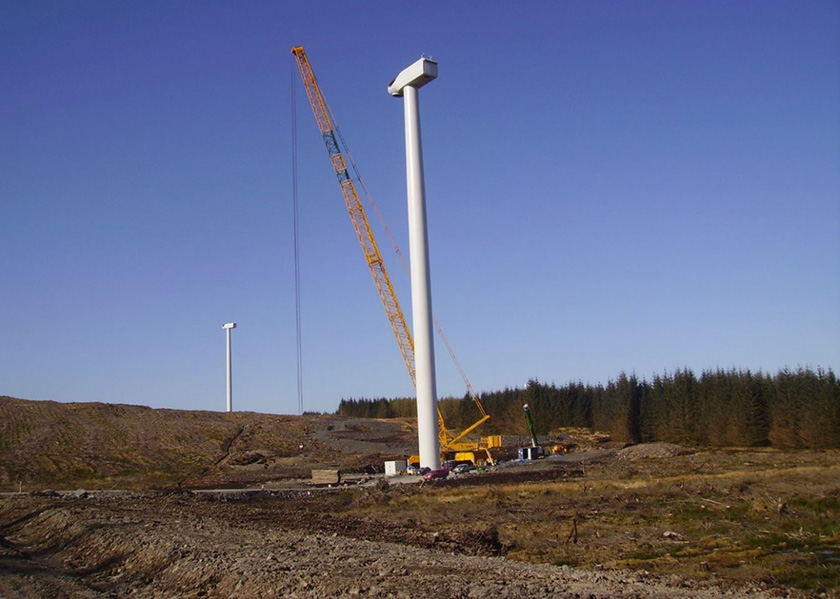
Above: SPR’s Kilgallioch Windfarm during construction, Kilgallioch hub height is 105 m, Hollandmey hub height will be 84 m
What we will do…
This Site is largely stocked with middle aged conifers and the aim will be to carry out keyhole felling to accommodate the turbines wherever possible to avoid adverse environmental impacts; this will also minimise both the amount of felling and the area of Compensatory Planting that may be required. Keyhole felling, as opposed to the alternative of clear felling, will not have as great an impact on the local environment. Keyhole felling aims to avoid woodland loss wherever possible and where this is not possible, to have the smallest possible area of felling within afforested areas. The size of the keyhole is dependent on a number of factors relating to the crop, turbine selection and other factors such as the presence of protected species.
A complete forestry assessment will be carried out to provide the information required by The Highland Council and Scottish Forestry and to provide all the necessary advice and information, including a complete assessment of the growing stock and the volume of timber that would need to be felled, as required for the Environmental Impact Assessment.
Design mitigation has been embedded into the Site design as a result of the Environmental Impact Assessment surveys where possible. Factors considered throughout the project development have taken cognisance of the following:
- Consideration of important viewpoints such as Dunnet Head and seeking to reduce the horizontal extent of the proposed Development;
- Consideration of how the proposed Development would fit with other windfarms in the area and cumulative effects on views;
- Turbines are located such that that they are at least 1 km away from the nearest noise sensitive receptor;
- We have sought to avoid areas of deep peat as far as practicable.
- Potential impacts on watercourses were minimised by retaining a suitable buffer from any of the site infrastructure where possible;
- The road layout used as much existing forestry road as possible, reducing the amount of new track and water crossings required for the construction of the proposed Development;
- Avoided any known designated assets;
- Appropriate stand-off distances were integrated into the Site design to ensure there is no impact on the underground power cables traversing the site.
In addition, SPR will ensure there are no detrimental effects for residents on their telecommunication services.
Go back to the main pageGo to the next page