The proposed application boundary is shown below:
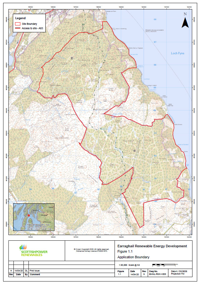
View a larger version of the map above
The application boundary is the same as the one included in our initial leaflet distributed to all properties within 4 km of the Site during the week of 22 June 2020.
Work Undertaken to Date
SPR already has a good understanding of the Site owing to the wealth of data gathered to date, which ranges from feasibility assessments to an ongoing programme of ornithology surveys.
The identification of environmental and physical constraints is particularly important at the start of any Renewable Energy Development (RED) project, as this helps to define a potentially developable area for project infrastructure.
We are now beginning the process of assessing the findings from the surveys completed to date. This information, together with results from the remaining surveys and comments from the online exhibition and key consultee feedback, will help to refine the design further if required.
The proposed Site layout, which takes account of all the known environmental and physical constraints identified to date, is shown below
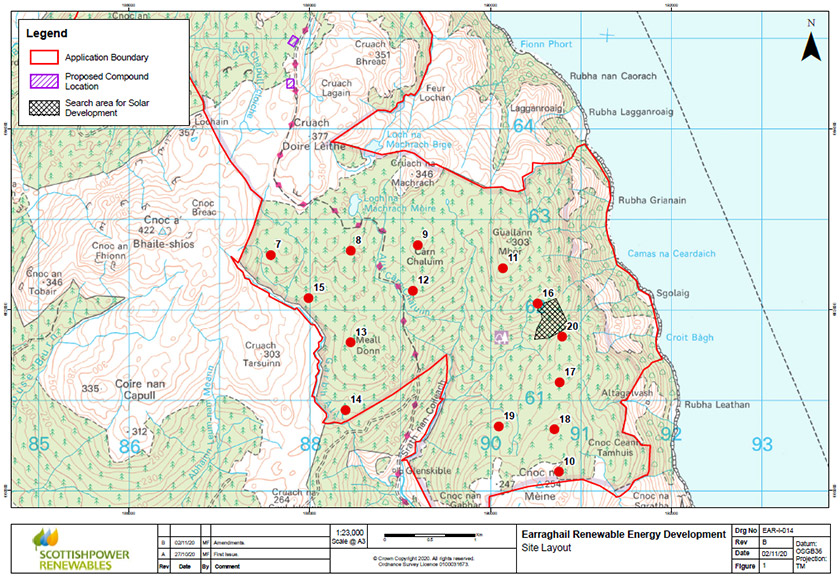
View a larger version of the map above
Key project details
 | 14 wind turbines with a maximum height to blade tip of 200 metres (m) |
 | Generating capacity of around 89 megawatts (MW), from wind turbines and solar panels |
 | Generating enough electricity to supply the equivalent of more than 50,000* households in Scotland |
*Calculation from Scottish Government website. 89 MW of onshore wind equivalent to 49,244 households in Scotland per year. 5 MW of solar photovoltaic power equivalent to 1,066 households
The Site consists of two forestry parcels named Skipness and Corranbuie, which are owned by Forestry and Land Scotland, in the northern part of the Kintyre Peninsula in Argyll and Bute. The proposed Development turbines are located approximately 2.5 km north of Skipness and 6 km south of Tarbert.
The Site was chosen for several reasons, including that
- It has an excellent wind resource onsite, which means good wind speeds for energy generation
- It can accommodate wind turbines and associated infrastructure without affecting national or internationally protected sites
- It is in close proximity to transport and grid connections and benefits from an existing commercial forestry track network.
The initial feasibility and design work undertaken in 2018 indicated that the Site had the potential to accommodate up to 57 commercial scale wind turbines across both the Skipness and Corranbuie land parcels. Further feasibility and environmental survey work has been undertaken since 2019. As a result, SPR has reduced the area being considered for turbines. Early in 2020, SPR proposed a development of about 13 wind turbines of up to 200 m to blade tip and an associated Energy Storage Facility with a solar photovoltaic park focused only on the Skipness land parcel. Following discussions with key consultees, including the Tarbert and Skipness Community Council, we have reassessed the capacity of the Site and identified that up to 14 turbines up to 200m to blade tip could be accommodated.
The design will look to find an appropriate balance between optimising the energy yield and minimising the environmental effects. This will be important to maximise the contribution the proposed Development would make to the Scottish Government’s renewable energy and climate change targets, and response to the climate emergency.
The final design of the proposed Development will be established through an iterative process that will take into account the identification of all the technical and environmental constraints determined through the Environmental Impact Assessment (EIA) process through consultation with statutory and non-statutory organisations and members of the local community.
In addition to the wind turbines, the proposed Development will include ground-mounted solar panels and an Energy Storage Facility. This will be used to store the green electricity produced by the wind turbines and solar panels. It could be used to smooth out variances between available resource and electricity demand. It could also be used to provide services to help stabilise the operation of the local electricity network.
The construction of the proposed Development is anticipated take up to 20 months. The commencement date has not been confirmed, but late 2024 is a realistic timeframe.
There is no proposal to limit the lifetime of the proposed Development. Therefore, the assessment of potential effects on all aspects will consider the operational phase of the proposed Development without time limitations.
As a result of this feasibility and design work, the key constraints were identified, and a proposed Site layout was identified with respect to these constraints.
The proposed Site layout in the context of these constraints is shown below:
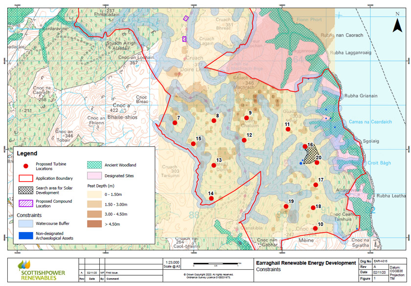
View a larger version of the map above
Development and Environmental Impact Assessment (EIA) process
Initial Site investigation and design | Initial Site viability and project feasibility assessment |
EIA scoping: April 2020 onwards | Identifying and agreeing with stakeholders what aspects and potential effects of the proposed Development should be covered by the EIA |
Public engagement: June 2020 | A leaflet was mailed to all properties within 4 km of the Site introducing the concept of the proposed Development. |
Onsite and desktop environmental surveys: ongoing | Research to establish what the conditions of the Site are today (known as the baseline) has been ongoing since 2019. The results of this will enable the effects of the predicted changes resulting from the proposed Development to be assessed within the EIA. |
Environmental Impact Assessment: Ongoing | An EIA is an iterative process for optimising the design to achieve balance between site performance and environmental effects. It is a formal part of the RED planning process that involves undertaking environmental surveys of the Site by independent specialists to quantify and identify any significant environmental effects the proposed Development may have. The EIA for Earraghail RED will assess the potential for effects from the following environmental topics: - Landscape and visual
- Noise
- Ecology
- Ornithology
- Archaeology and cultural heritage
- Access, traffic and transport
- Ecology and biodiversity
- Hydrology, hydrogeology, geology and soil
- Other issues, including forestry and land use, aviation and radar, telecommunications, climate and carbon balance.
- Cumulative effects.
The EIA will also seek to identify measures to eliminate, avoid, reduce or mitigate any potential significant effects, where possible. |
Public consultation: autumn/winter 2020 | The current Public Information Event |
Design evolution: ongoing | Iterative process to optimise the design to achieve balance between Site performance and environmental effects. |
Submission of Application for Consent: Summer 2021 | We will submit an application to build and operate the proposed Development to the Scottish Ministers for determination under Section 36 of the Electricity Act 1989. |
Evaluation and determination of the application | The Section 36 application will be administered by the Scottish Government Energy Consents Unit (ECU) on behalf of the Scottish Ministers. There will be an opportunity at this stage for you to make formal representations on the application to the ECU. These will then be taken into account by the Scottish Ministers when determining whether to grant consent for the proposed Development. The timescales for determination are variable and dependent on case-specific issues but typically take between 12 to 15 months. |
Go back to the main pageGo to the next page