Feasibility assessments were undertaken from 2018, and surveys were undertaken from 2019. We undertook a formal EIA scoping process with the ECU in April 2020 that helped to define the baseline conditions for the Site and understand the nature of the Site and surrounding area. This advice has been used to inform the proposed Development layout and scope of the EIA.
Understanding the potential for a development to affect habitats, birds and other species is an important part of site design and the EIA process.
We Have…
We have undertaken a series of desk-based studies and consultations with organisations including NatureScot, the RSPB and local fisheries boards to identify existing records of species and habitats; conducted baseline ecological surveys onsite for protected species and habitats; and undertaken baseline ornithological surveys, including breeding and wintering bird, and flight activity surveys, from 2019 onwards.
We Found…
The Site primarily consists of commercially managed forestry interspersed with pockets of wet and dry heathland and grassland. The eastern part of the Site near Loch Fyne forms part of the Tarbert Wood special area of conservation and the Tarbert to Skipness coast site of special scientific interest (SSSI).
There are two internationally designated areas nearby that will require consideration (along with their component SSSIs) in our ornithology assessments: Knapdale Lochs special protection area (SPA) (approximately 7.6k m north-west of the application boundary) and Kintyre Goose Roosts SPA and Ramsar site (approximately 14.4 km south-west).
A comprehensive suite of ecological and ornithological surveys is under way for the Site.
What We Will Do…
We will continue our remaining ecological and ornithological surveys and identify any sensitive species and habitats that require changes to the proposed Development design.
No parts of the proposed Development will be located within any of the protected sites identified, but we will explore opportunities to improve sensitive and protected habitats as part of the project.
Protecting Species and Habitat
We will seek to mitigate impacts on ecology by
- Avoiding construction during the bird breeding season where possible, or where impossible, undertaking surveys to identify and protect any nesting birds
- Avoiding watercourses and areas of sensitive blanket bog habitats identified during the Phase 1/National Vegetation Classification vegetation surveys
- Adopting safe working buffers where protected species are found
- Adopting pollution control measures to prevent silt and dust entering watercourses
- Designing any new or upgraded watercourse crossings to maintain the safe passage of fish.
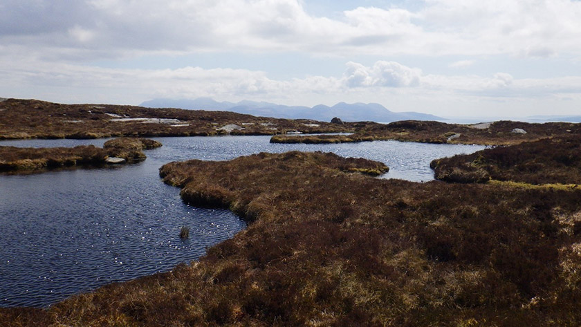
Above: View of a lochan located within the Site
Any potential adverse effects on any species will be mitigated to meet legislative requirements and good practice; species-specific mitigation plans will be created where required.
SPR will also identify opportunities for ecological enhancement, either through onsite habitat management or through consultation with conservation organisations to support existing biodiversity projects.
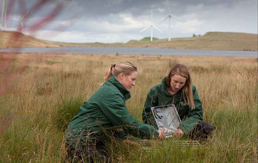
Above: SPR’s in-house ecology team conducting onsite fieldwork.
Our understanding of the ground conditions and surface water network has informed the Site design. This minimises the risk of groundwater and surface water being adversely affected. Our technical specialists work closely with each another to ensure that the potential effects of the proposed Development on hydrology and related habitats and species are considered holistically. This is particularly important for groundwater dependent terrestrial ecosystems, for example.
We Have…
We have assessed the watercourses on the Site and avoided them as far as possible during the design process; investigated peat depths across the Site; and identified the location of private water supplies near and downstream of the Site and the potential for flooding from watercourses on the Site.
We Found…
Our technical specialists have identified the key hydrological components in and around the proposed Development. This enables us to understand how rainfall and surface water runoff infiltrate soil and peat and discharge into watercourses and drainage channels.
This information will also enable us to assess whether any private water supplies are potentially at risk of being affected by construction work.
The preliminary peat surveys identified peat deposits of variable depth across the Site, including some areas without peat. Our initial design avoided the areas of deepest peat.
What We Will Do…
Further peat surveys will be undertaken to provide key information to the design team to enable peat bodies to be avoided as far as possible by careful siting and design. Where peat cannot be avoided, location-specific mitigation measures will be set out to minimise the effects on the peat. This is planned to include peatland restoration proposals for suitable areas.
Protecting Watercourses During Construction
During the construction phase, pollution of water entering watercourses will be prevented through a range of measures, including the use of silt traps, settlement ponds and cutoff drains, and a surface water monitoring programme. This is to ensure that the water quality in all the downstream watercourses is protected and maintained.
Archaeology relates primarily to the buried remains and artefacts that could be affected by construction work related to the building of the proposed Development.
Cultural heritage generally relates to other sites, features and locations in the wider landscape that have the potential to have their settings affected by the proposed Development.
We Have…
We have undertaken a desk-based assessment of the Site and the surrounding areas to identify all the known assets registered with national and local archaeological bodies.
We Found…
There are no designated heritage assets (World Heritage Sites, Inventory historic battlefields or Inventory gardens and designed landscapes) within the application boundary. Thirteen undesignated assets recorded in the Canmore database were identified onsite. These are prehistoric cup-marked stones and house platforms, and other more recent assets related to post-medieval crofting.
Several designated assets are present within 20 km of the Site. Of these, we will focus attention on the scheduled monuments of Skipness Castle; Kilbrannan Chapel; Dun Skeig; Lochranza Castle, Arran; Tarbert Castle and medieval burgh; and the Inventory garden and designed landscape around Stonefield Castle.
What We Will Do…
Heritage assessments are ongoing and will be informed by the findings and analysis of other environmental studies and feedback from consultees. A Site walkover will also be undertaken to confirm the condition of the known heritage assets and to inspect the Site for any previously unknown features. Visits will also be made to heritage assets in the surrounding area; visualisations will be produced to illustrate views of the proposed Development from those assets and to inform the assessment of potential setting effects.
We will explore opportunities to improve local understanding and engagement with heritage assets within the Site.
Protecting Assets During Construction
An archaeological watching brief is proposed during construction to identify, record and, where appropriate, protect any remains that are discovered. Known features onsite will also be protected with buffer zones and visible barriers to minimise the risk of accidental disturbance.
We Have…
We have undertaken a detailed study of the noise environment. This included using existing background noise data from similar projects and noise modelling to predict likely levels of wind turbine noise. The existing and predicted levels of wind turbine noise will be considered against the current guidance to determine whether the scale of impacts will be significant.
We Found…
The nearest noise-sensitive receptors considered to be representative of residential dwellings in the immediate vicinity have been identified. The potential impact of noise from the proposed Development has been continuously assessed during the design process, and the layout has been refined through the appropriate siting of turbines in relation to the noise-sensitive receptors.
What We Will Do…
We will undertake a programme of noise surveys for the properties closest to the proposed Development. Noise assessments are ongoing and will be completed after feedback from consultees and finalisation of the design.
Protecting Residents During Construction
Noise from construction activities will be controlled through the use of a construction environmental management plan..
We Have…
Undertaken a preliminary assessment of the potential impacts on access, traffic and transport. This considered the potential effects of the proposed Development on the transport network, primarily in relation to construction vehicles and the delivery of wind turbine components.
Further studies also considered the route to the Site from the nearby proposed port of entry and the potential for environmental effects from vehicles using the public road network.
We Found…
Abnormal load access is anticipated to be from the A83 through bringing the turbine components from either Campbeltown Harbour or the CS Wind UK tower manufacturing facility at Machrihanish. The existing network of engineered timber haulage roads on the Site will be utilised to minimise ground disturbance where possible.
What We Will Do…
Traffic and transport assessments are ongoing. These routes will be assessed in detail during a route access study that will also consider alternatives to ensure that the most appropriate route is chosen.
We will undertake a detailed assessment of the potential impacts on access, traffic and transport that will be informed by the findings and analyses of other environmental studies and feedback from consultees.
Protecting Road Users and Residents
The delivery of wind turbine components to the Site during construction will require careful management. To minimise the impact on local residents and other road users, a construction environmental management plan and a construction traffic management plan will be produced in agreement with Argyll and Bute Council before construction starts. These will detail any mitigation measures if applicable. As a minimum, the following measures will be taken:
- Construction vehicles will use approved access routes and adhere to any necessary restrictions.
- Appropriate temporary signage will be erected in the vicinity of the Site warning of construction traffic and warning other road users of abnormal load turbine movements.
- Abnormal loads will be escorted from the port of entry to timings agreed with the road authorities and police, as appropriate.
- Ground preparation will include the protection of services.
- Arrangements will be made for road maintenance, wheel washing and road sweeping, where necessary.
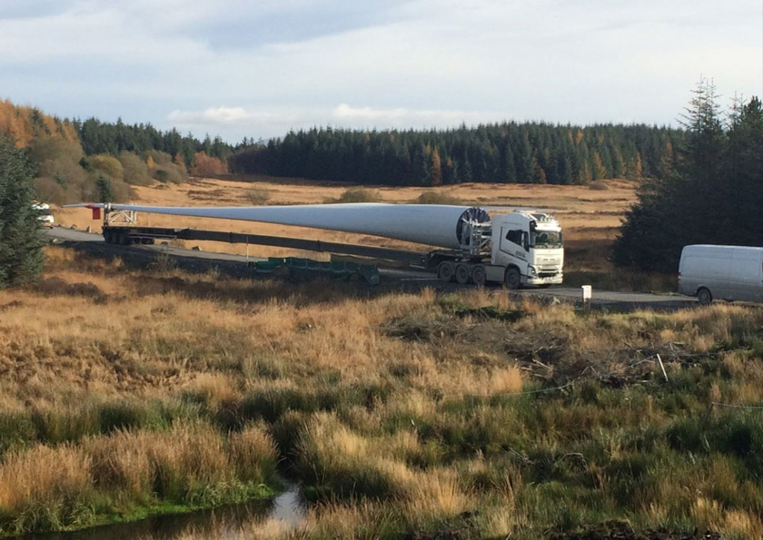
Above: A delivery vehicle with a 57 m blade; Earraghail blades will be up to 75 m long.
An assessment of the potential socio-economic, tourism and recreation impacts of the proposed Development is being undertaken as part of the EIA report.
We Have…
We have reviewed the existing baseline conditions, including the identification of local interest groups, tourist attractions and public access. We have also examined the publicly available information on socio-economic baseline and trends for the Site and the surrounding area.
We have engaged with Kintyre Way, a Scottish Charitable Incorporated Organisation, and will continue to do so as our plans progress. Other local interest groups were included during the scoping consultation. This gave them the opportunity to consider the proposed Development and assist with the collection of baseline data, scrutinise the proposed scope of and approach to the EIA, and provide feedback regarding any concerns they might have.
An assessment of the potential effects of the proposed Development against these baseline conditions will be undertaken as part of the EIA.
We Found…
The construction and operation of the proposed Development has the potential to benefit the local and regional economies through direct construction and operation employment opportunities and indirect employment further down the supply chain for those companies providing services to the contractors during the construction and operation phases of the development.
What We Will Do…
Assessments are ongoing and will be informed by the findings and analysis of other environmental studies and feedback from consultees.
As a minimum, we are committed to
- Seeking to use local labour and supply chains where practical to maximise the benefits to the local economy
- Making provision for access during the operation of the proposed Development, though there may be some restrictions on access to the Site during construction for health and safety reasons
- Continuing to consult with recreational groups to identify and respond to any opportunities and areas of concern
- Engaging with local schools and educational establishments to share knowledge and build relationships
- Working with the community to develop the community benefit and investment opportunities in a way that responds to their needs.
Wind turbines have the potential to interfere with military and civil aviation operations, primarily through their effects on surveillance radar and communication and navigation equipment, but also as physical obstructions if they are sited within military low-flying areas.
We Have…
We have consulted with the relevant stakeholders (Ministry of Defence, Civil Aviation Authority, NATS, Highlands and Islands Airports, and Edinburgh, Glasgow and Glasgow Prestwick airports) in order to understand the current context and to identify any constraints.
We Found…
No concerns have been raised by the Ministry of Defence relating to the proposed Development. Discussions with civilian aerospace consultees are ongoing; however, the proposed Development is not in an area typically used by commercial aircraft using Scotland’s airports.
What We Will Do…
An assessment of civil and military aviation issues will be undertaken. Input will be obtained from specialist consultants should any issues be identified that require mitigation or detailed technical assessment, including line-of-sight assessments.
Wind turbines can potentially cause interference with telecommunication system signals through reflecting and shadowing signals between transmitters and receivers.
We Have…
Undertaken consultation with the relevant bodies to establish the presence of utilities and telecommunication links across the Site. We have conducted a telecommunications impact assessment to identify the links that might be affected by the proposed Development and the potential mitigation measures.
We Found…
The Joint Radio Company, Ericsson (MBNL/EE), Atkins, Arqiva, Vodafone and British Telecom have confirmed they have no concerns regarding the proposed Development.
What We Will Do…
Any further information on communication links will be sought through consultation with the relevant link operators. An assessment will be undertaken to determine the significance of any potential operational effects and, where appropriate, suitable mitigation measures will be discussed with the link operator.
Shadow flicker is caused by the rotation of the turbine blades when the sun is shining, which can create a flickering or strobe-like effect. This can be a cause of annoyance at residences near wind developments.
We Have…
We have reviewed the regional and national policy on shadow flicker and identified residential properties within 2 km of the application boundary.
We Found…
There are no formal guidelines currently available on what exposure would be acceptable in relation to shadow flicker. There is no standard for the assessment of shadow flicker. The Scottish Government’s web-based guide relating to onshore wind turbines (Scottish Government 2013) suggests that, as a general rule, shadow flicker should not pose problems beyond a distance of ten rotor diameters from a wind turbine, which equates to a maximum of 1500 m in this instance.
Department of Environment and Climate Change studies have shown that, in northern latitudes, shadows from wind turbines can only be cast 130 degrees either side of north relative to the turbine owing to the orientation of the earth’s axis and the positioning of the sun.
This equates to a region of 50 degrees either side of due south where a wind turbine would never cast a shadow, so properties within this region would experience no effects from shadow flicker.
What We Will Do…
The proposed Development will be designed to avoid turbine placements within the zone of potential shadow flicker.
The inclusion of solar panels will be confirmed through the design process. If they not included in the final design, there would be no requirement to assess these potential effects in the EIA.
Solar panels have varying reflectivity properties; however, no solar panel absorbs 100% of the incoming light. As a result, solar panels have the potential to produce solar reflection in the form of solar glint (a momentary flash of bright light) and solar glare (a continuous source of bright light). Solar glint may be witnessed by moderate-to-fast-moving receptors, whereas solar glare may be encountered by static or slow-moving receptors with respect to a solar development.
We Have…
We have reviewed the guidance, current studies and consultation responses and have proposed a study area, including dwellings, road users, railway users and aviation receptors, and a methodology for assessing solar glint and glare effects.
What We Will Do…
An assessment of solar glint and glare will be undertaken. Input will be obtained from the specialist consultants should any issues be identified that require mitigation or detailed technical assessment.
The proposed Development, once operational, would generate zero-carbon energy, which would help to offset the release of greenhouse gas emissions from fossil-fuel-dependent energy generation. During their construction and decommissioning, however, renewable energy developments can themselves result in greenhouse gas emissions, for example, from turbine manufacture and site preparation. This is particularly the case when natural carbon stores such as forestry or peat are present and potentially affected by the development.
We Have…
We have avoided siting wind turbines within the areas of deepest peat throughout the initial design process.
What We Will Do…
To minimise peat disturbance during construction, especially during excavation, best practicable measures will also be considered that will be provided as part of the construction environmental management plan.
A carbon balance assessment will be prepared in accordance with good practice guidance to outline the time taken for the carbon impact of the development to be reversed by the zero-carbon electricity generation.
The current land use of the Site is an active commercial forest with ongoing felling and restocking carried out as part of an approved land management plan, as agreed with Scottish Forestry.
We Have…
We have undertaken a desk-based review to understand the nature of the forestry onsite.
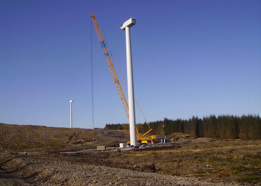
Above: SPR’s Kilgallioch Windfarm during construction. Wind turbines in the image have a hub height of 105 m and are up to146.5 m to blade tip height. The proposed turbine hub height at Earraghail RED will be up to 125 m and up to 200 m to blade tip
What We Will Do…
We will produce a development forest design plan as part of the EIA process incorporating the proposed Development into the forest structure. The proposed development felling plan would show which woodlands are to be felled to facilitate the proposed Development and the restocking plan would show how the forest will be restocked during the life of the proposed Development.
We aim to carry out keyhole felling to accommodate the turbines wherever possible to avoid adverse environmental impacts; this will also minimise both the amount of felling and the area of compensatory planting that may be required. Keyhole felling aims to avoid woodland loss wherever possible and, where this is not possible, to have the smallest possible keyhole and associated felling within afforested areas. The size of the keyhole is dependent on factors relating to the crop and turbine selection and other challenges such as the presence of protected species.
A complete forestry assessment will be carried out to provide the information required by Argyll and Bute Council and all the necessary advice and information, including a complete assessment of the growing stock and the volume of timber that would need to be felled, required for the EIA.
We will consult with the land managers, Forestry and Land Scotland, and Scottish Forestry as part of the process..
Several design mitigation measures have been embedded into the Site design as a result of the EIA surveys, where possible. These include
- Minimising the prominence of the proposed Development in views from the North Arran national scenic area (and special landscape area) and the Argyll and Bute Council areas of panoramic quality
- Reducing visibility from the surrounding roads and routes, including the A83, the B8001, the Kintyre Way and nearby ferry routes
- Consideration of how the proposed Development would fit with other windfarms in the area and the cumulative effects on views
- Locating wind turbines so that that they are at least 1 km away from the nearest noise-sensitive receptor
- Seeking to avoid areas of deep peat as far as practicable. Impacts on watercourses have been minimised by retaining a buffer of 50 m from any of the turbines, crane pad hardstanding, temporary compounds or the substation in the Site design.
- Ensuring the road layout uses as much existing forestry road as possible and reducing the amount of new track and water crossings required for the construction of the proposed Development
- Avoiding any known designated assets through applying a buffer zone
- Ensuring there are no detrimental effects for residents on their telecommunication services.
Go back to the main pageGo to the next page