Establishing a detailed ecological record of the Site enables us to develop the layout in a manner that avoids or minimises adverse effects on sensitive habitats and protected species.
We have:
Undertaken a series of desk-based studies and consultations with organisations including NatureScot, Royal Society for the Protection for Birds (RSPB), Galloway and Southern Ayrshire UNESCO Biosphere and Ayrshire Rivers Trust.
Undertaken baseline ecological surveys on Site for protected species and habitats.
Undertaken bird flight activity surveys since September 2018 at the Site in addition to breeding bird, black grouse, breeding raptor, and nightjar surveys.
We found:
The Site does not overlap with any statutory designated sites of nature conservation interest. The closest such site is Auchalton Site of Special Scientific Interest (SSSI) which is located approximately 1.4km to the north of the Site and is designated for its lowland neutral grassland habitat. Merrick Kells Special Area of Conservation (SAC) and SSSI, which is designated for its upland and acidic terrestrial and freshwater habitats, associated vegetation and otter population is located approximately 5km to the south of the Site.
The habitats on Site are dominated by standing and recently clear-felled coniferous plantation forestry interspersed with rides and open areas comprising bog, wet heath, acid grassland and several minor watercourses / forest drains, most of which are modified, fragmented and degraded from forestry activities. This provides a suitable habitat for a number of species under varying levels of protection.
The surveys have found evidence of protected species including otter, bats, pine marten and water vole, as well as potentially suitable habitat for salmonid fish and freshwater pearl mussel. Bird surveys to date have shown presence of breeding ospreys and peregrine. Hen harrier, goshawk, merlin and black grouse are also present but have not been recorded successfully breeding
Protecting Species:
SPR will seek to mitigate impacts on ecology and ornithology in a variety of ways:
- Avoiding construction during the bird breeding season where possible or, where not possible, undertaking surveys to identify and protect any nesting birds.
- Designing windfarm layout to minimise any impacts on bird flight activity.
- Pollution control measures to prevent silt, dust or hydrocarbons entering watercourses.
- Designing any new or upgraded watercourse crossings to maintain safe passage of fish and riparian mammals.
Any potential adverse effects for any species will be mitigated to meet the applicable standard and species-specific mitigation plans will be created for protected species, as required.
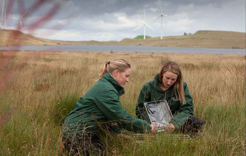
Above: SPR’s in-house ecology team conducting onsite fieldwork.
Archaeology relates primarily to the buried remains and artefacts that could be affected by the construction works related to the building of the Proposed Development.
Cultural heritage also relates to other sites, features and locations in the wider landscape which have the potential to have their setting affected by the Proposed Development.
We have:
Undertaken a desktop assessment to identify all known assets registered with national and local archaeological bodies, as well as a site walkover to identify any previously unknown assets within and nearby to the Site.
We found:
No World Heritage Sites, Inventory Battlefields, or Inventory Garden and Designed Landscapes within the Site Boundary.
We encountered a number of designated sites surrounding the Proposed Development including the Scheduled Monument of Knockinculloch enclosures and Bencallen Hill Chambered Cairn.
We encountered another 27 undesignated assets during our studies ranging from sheep rees and shieling huts to quarries.
Protecting assets:
Known assets have been avoided within the proposed design layout. Archaeological mitigation is proposed to take place during construction to identify, record and, where appropriate, protect any unknown archaeological remains that are uncovered.
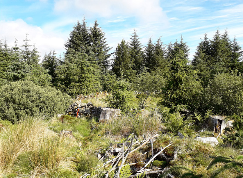
Above: Sheep ree at Carrick, taken during fieldwork in Summer 2020.
We have:
Monitored existing background noise at representative properties surrounding the Site. The data obtained has been analysed using specialist software to inform an assessment of potential noise generation during the construction and operational phase of the Proposed Development.
Agreed the scope and approach to the required noise assessment work with South Ayrshire Council, including that a cumulative assessment of potential operational phase noise will be undertaken.
We found:
The potential impact of noise from the Proposed Development has been continuously assessed during the design process, and the layout refined through the appropriate siting of wind turbines in relation to identified residential properties.
Protecting residents during construction:
The majority of construction works will generally be undertaken at substantial distances from local residents, minimising the potential for any significant noise or vibration effects to arise. Notwithstanding this, noise from construction activities will be controlled through use of a Construction Environmental Management Plan (CEMP).
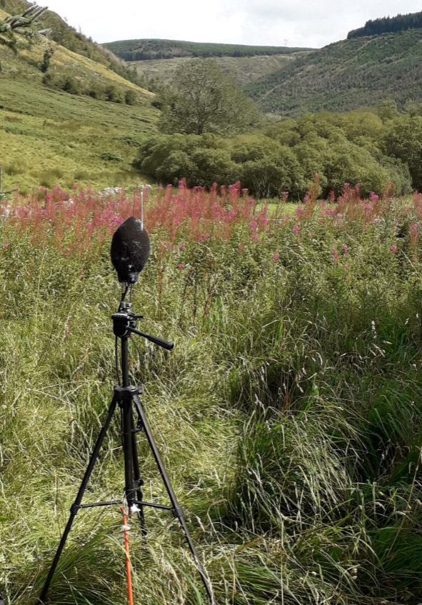
Above: Noise monitoring equipment installed at location agreed with South Ayrshire Council - August 2020.
Our understanding of the ground conditions and surface water network has informed the Site design. This minimises the risk of groundwater, surface water and areas of peat being adversely affected. Our technical specialists work closely with one another, following a multidisciplinary approach, to ensure that the potential effects of the Proposed Development on hydrology, related habitats and species are considered holistically. This is particularly important for groundwater dependent terrestrial ecosystems.
We have:
Avoided watercourses on Site as much as possible.
Undertaken surveys and desk assessments to understand the hydrological and hydrogeological conditions at the Site to inform the design and to minimise the risk of groundwater and surface water being adversely affected.
Undertaken peat depth surveys, identified the location of private water supplies and the potential for flooding from the watercourses. This data has fed into the design of the Proposed Development.
We found:
Our technical specialists have identified the key hydrological components within and connected to the Proposed Development. This allows us to understand how rainfall and surface water runoff infiltrates soils (including peat), and discharges into watercourses and artificial drainage channels.
This information has also allowed us to assess whether any private and public water supplies are potentially at risk of being affected by construction works.
The peat surveys revealed that there are varying depths of peat across the Site (particularly in the south of the Developable Area), with some localised pockets of deeper peat.
Protecting watercourses during construction:
During the construction phase, pollution of watercourses will be prevented through a range of good practice, such as the use of silt traps, settlement ponds and cut off drains. This is to ensure that water quality of watercourses, such as River Stinchar, Water of Girvan and Palmullen Burn, are protected and maintained.
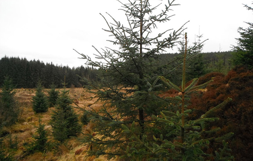
Above: A forest clearing within the centre of the Site during the phase 1 peat probing survey – March 2020.
We have:
Assessed the potential impacts on access, traffic and transport. This has considered the potential effects on the Proposed Development on the transport network, primarily in relation to construction vehicles. This assessment also considered the delivery route of the main wind turbine components to the Site from the nearest suitable ports, and the potential for environmental effects of vehicles using the public road network.
We found:
There are a number of different access routes available for general construction traffic to access the Proposed Development from the wider road network, approaching the Site from both the north and south on the C46W. The route choices have been influenced by a number of factors, including but not limited to local sensitive receptors, road category, local infrastructure (i.e. bridges) and previous use for similar types of development. The routes being considered are illustrated below.
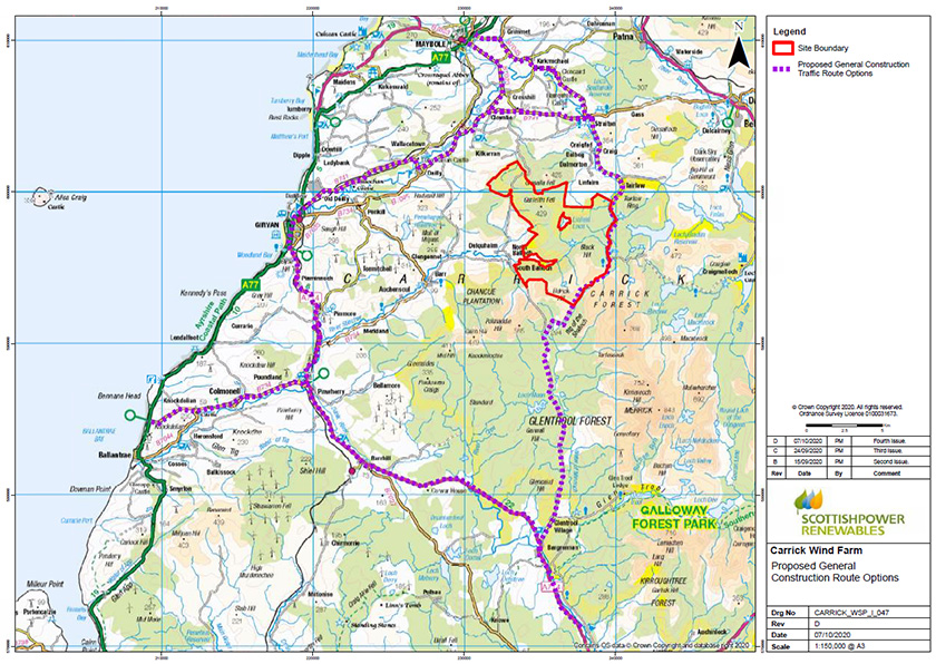
View a larger version of the map above
With regards to abnormal load movements associated with the movement of wind turbine components to the Proposed Development, it is currently proposed that these would be delivered to Glasgow King George V Dock. They would then be transported to the Site via the following routes: Kings Inch Drive, M8, M74/M6, A75, U52W, A714 and the C46W to the proposed Site access junction. Part of this route is shown on the figure below and is likely to require upgrade and widening works at certain points along the route.
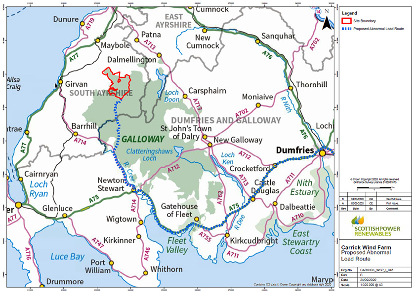
View a larger version of the map above
Protecting road users and residents:
Delivery of the larger wind turbine components to Site during construction will require careful management. In order to minimise the impact on local residents and other road users, prior to commencing construction, a CEMP and a Construction Traffic Management Plan (CTMP) would be produced in agreement with South Ayrshire Council detailing mitigation measures if applicable. As a minimum, this will include measures such as:
- Construction vehicles to use approved access routes and adhere to any necessary restrictions.
- Erection of appropriate temporary signage in the vicinity of the Site warning of construction traffic and warning other users of abnormal load turbine movements.
- Abnormal loads will be escorted from the port of entry with timings agreed with the road authorities and police as appropriate.
- Ground preparation, including protection of services.
- Arrangements for road maintenance, wheel washing and road sweeping where necessary.
Once operational, impacts on traffic and transport from the Proposed Development are anticipated to be minimal, with SPR Operations staff attending Site and one or two small service vehicles regularly accessing the Site to carry out routine maintenance.
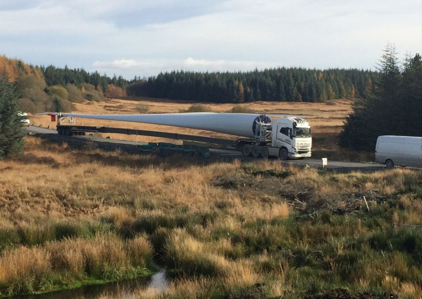
Above: Blade image shows delivery vehicle with 57 metre blade, Carrick blades will be up to 75 metres in length.
An assessment of the potential socio-economic, tourism and recreation impacts of the Proposed Development is being undertaken as part of the Environmental Impact Assessment Report.
We have:
Reviewed the existing baseline conditions and consulted with various stakeholders to identify local recreational groups, tourist attractions, business/employment conditions and SPR’s community benefit schemes in the region.
Consulted with South Ayrshire Council regarding recreational routes as well as communicating with the local Community Councils and Forestry and Land Scotland.
We found
There are existing recreational routes located within the Site Boundary. These comprise Core Paths, a heritage path, rights of way, Scottish hill tracks, National Cycle Network and operational forest roads. The Site Boundary also lies within several recreational assets, including the Galloway Forest Park, Galloway and South Ayrshire Biosphere, Galloway Dark Skies Park Core and Buffer Zones, and Tairlaw car park and picnic area. All turbines and associated windfarm infrastructure have been designed to be out with the Galloway Dark Skies Park Core Zone.
The construction and operation of the Proposed Development has the potential to benefit the local and regional economies through:
- Direct construction and operational employment opportunities.
- Indirect employment further down the supply chain for those companies providing services to the contractors during the construction and operational phases of the Proposed Development.
What we will do:
- We will seek to use local labour where practical to maximise the benefits to the local economy.
- Whilst there may be some restrictions on access to the Site during construction for health and safety reasons, we are committed to making provision for access during the operation of the Proposed Development.
- We will continue to consult with recreational groups to identify and respond to any opportunities and areas of concern.
- We will seek to engage with local schools and educational establishments to share knowledge and build relationships.
- We will work with the community to develop the Community Benefit and investment opportunities in a way that responds to their needs.
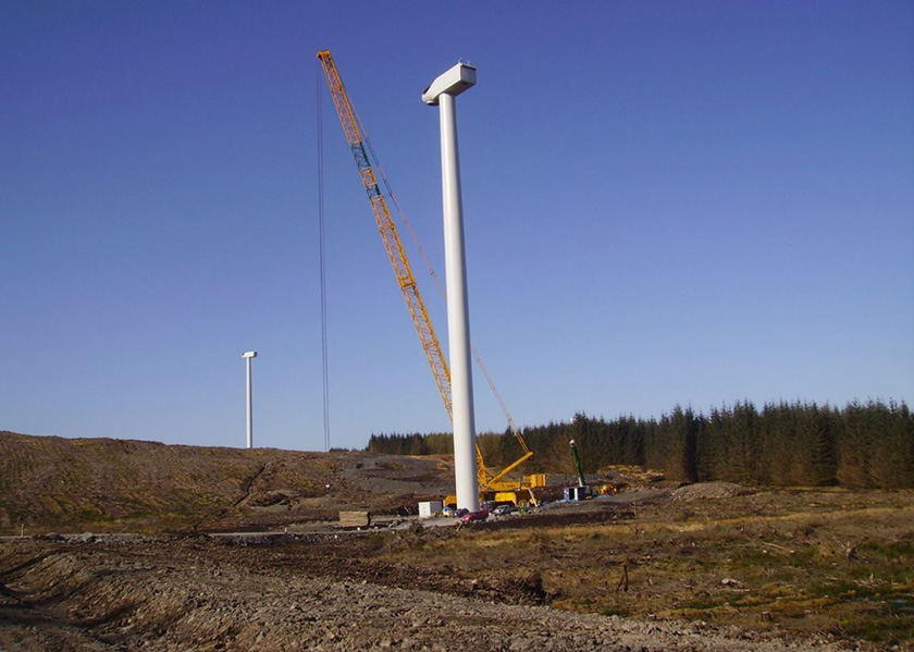
Above: SPR’s Kilgallioch Windfarm during construction. Wind turbines in image are up to 146.5 metres to blade tip in height. The proposed turbine height at Carrick Windfarm will be up to 200 metres to blade tip in height.
We have:
Undertaken an assessment on forestry and land use and consulted with the land managers, Forestry and Land Scotland, and Scottish Forestry as part of the process.
We found:
The current land use of the Site is an active commercial forest with ongoing felling and restocking being carried out as part of an approved Land Management Plan, as agreed with Scottish Forestry.
What we will do:
A Development Forest Plan will be prepared as part of the Environmental Impact Assessment process incorporating the Proposed Development into the forest structure. The Proposed Development Felling Plan would show which woodlands are to be felled to facilitate the Proposed Development and the Restocking Plan would show how the forest will be re-stocked during the life of the Proposed Development.
Construction of the Proposed Development would retain as much forestry as possible by minimising felling using a ‘key-holed’ approach for wind turbines. We will seek to maximise replanting on Site thereby minimising the loss of woodland area and enabling the land managers to continue to meet their management objectives for Carrick Forest.
Wind turbines have the potential to cause an impact on military and civil aviation operations, primarily through effects on radar and the air traffic service provided using impacted radars.
We have:
The project team has consulted with relevant stakeholders (Ministry of Defence (MoD), Civil Aviation Authority (CAA) and NATS) and has also undertaken an assessment in relation to aviation activity in the area.
We found:
Our initial aviation assessment suggests that some of the wind turbines may be visible to MoD and NATS radar, although whether there is a detriment impact on the air traffic service provided has not been determined.
What we will do:
Should there be a demonstrated detrimental impact on either MoD or NATS air traffic service, we will explore appropriate mitigation options with the relevant aviation stakeholder, to ensure that airspace remains safe.
We have:
Undertaken consultation with relevant bodies to establish the presence of telecommunication links across the Site.
We found:
SP Energy Networks (SPEN) operate a power line which runs through the centre of the Site, south of the turbine locations.
A number of design mitigations have been embedded into the Site design as a result of the Environmental Impact Assessment surveys. These include:
- Aiming to achieve a more coherent single cluster of wind turbines, avoiding splitting the layout into separate groups and subsequently extending the horizontal extent.
- Seeking to avoid locating wind turbines near to areas of deep peat as far as practicable.
- Minimising impacts on watercourses by retaining a buffer of 50 metres from any of the wind turbines, crane pad hardstandings, temporary compounds or the substation in the site design.
- The road layout uses as much existing forestry road as possible, reducing the amount of new track and water crossings required for the construction of the Proposed Development.
- The Proposed Development design avoids any known designated assets through applying a buffer.
- Integrating appropriate standoff distances into the Site design to ensure there are appropriate distances from wind turbines to the recreational routes and the SPEN power line.
Go back to the main pageGo to the next page